If all languages A to Z do not appear on your screen use Tab to select, then hit Enter
Click on any item to select hidden text
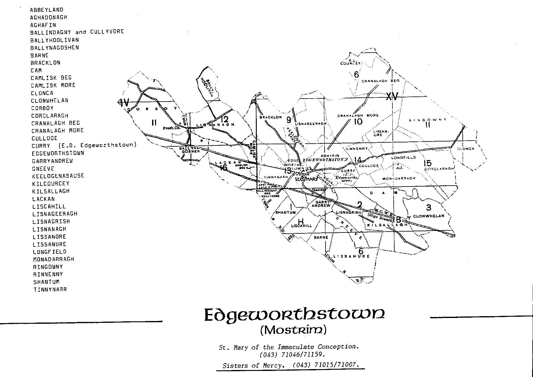
TOWNLANDS IN EDGEWORTHSTOWN PARISH – PARÓISTE MEATHAS TROIM
(Click on the map to expand it)
In Mostrim (Edgeworthstown) Civil Parish there are 34 townlands.
In St. Mary’s Edgeworthstown Roman Catholic Parish there are 38 townlands.
The additional four townlands are at the western end of the parish and are Corboy, Ballyhoolivan, Ballynagoshen and Lisnanagh. These are included in Killoe Civil Parish.
| Name of Townland | Logainm | Meaning of Name | |
| Abbeyland | Fearann na Mainistreach | Fearann = ploughland | |
| **** | Probably the abbey was the Fransiscan friary of St. John the Baptist, Ballynasaggart which was destroyed by Richard Nugent, Earl of Westmeath in 1651 |
||
| Aghadonagh | Achadh Donncha | ||
| Aughafin | Achadh Fionn | Fine field | |
| Ballindagney and Cullyvore | **** | Baile an Deagánaigh agus An Chúil Mhór (Coill Uí Mhordha?) | Town of the stronghold (Ballindagney) |
| Ballyhoolivan | Baile Uí Shúileacháin | O'Sullivan's town | |
| Ballynagoshen | Baile na gCosánach | Town of the footmen | |
| Barne | An Bhearna | Gap | |
| Bracklon | **** | Breac-chluain | Speckled town or Breac Linn (Speckled pool) |
| Cam | **** | Camach | A winding As in a long winding lane |
| From Cam is derived comma (because it is crooked) used in pronunciation. Caman, a hurly, a stick with a crooked head. Cambutta, a walking stick. |
|||
| Camlisk Beg | Camlaisc Bheag | Camlisk = Winding of the lazy man | |
| Canlisk More | Camlaisc Mhór | ||
| Clonca | **** | Cluain Catha | Meadow of the battle |
| Clonwhelan | Cluain Faolain | Cloonwhelan = Meadow of the seagulls | |
| Corboy | * **** | An Chorr Bhuí A byname composed of the elements corr ‘crane’ + buidhe ‘yellow’ Or Cor Buí = Yellow whin |
|
| Corclaragh | An Chorr Chlárach | A dyke with plank across | |
| Cranalagh Beg | **** | Crannalach Bheag | Cranalagh = trees or plantations |
| Cranalagh More | Crannalach Mhór | ||
| Culloge | Collóg | Little back – one who rides behind another on horseback | |
| Curry | * | Na Curraithe |
|
| Cuirreach or as it is written in modern Irish, currach, has two meanings, a racecourse and a morass. In it’s first sense it gives name to the Curragh of Kildare, which has been used as a racecourse from the most remote ages. In the second sense, which is the more general, it enters into names in the forms Curra, Curragh and Curry, which are very common through the four provinces -- Joyce (p.463) |
|||
| Edgeworthstown | Meathas Troim - Mostrim | Edgeworthstown or Mostrim - Meathustruim means the fertile ridge |
|
| This place-name is seldom seen except in Church Records. The place is better known by the name Edgeworthstown, after the Edgeworth family, who have been living here for the past two or three hundred years. Maria Edgeworth, a member of this family, wrote well in the English tongue. About twenty perches to the west of the ruins of the old Abbey (about which I could gather nothing) is St. Bearach's (Barry) holy well, now unknown and unheeded. He was the same who lived at Tarmonbarry. St. Bearach was probably the patron saint of Meathustruim. This parish is now (I think) under the tutelage of the Blessed Virgin Mary, feast 15th August. Dr. Healy tells us that every diocesan patron and almost every parochial saint had his holy well, of which the memory is now sometimes lost. I believe St. Barry and his holy fountain no longer hold a place in the memory of the people of Mostrim. Perhaps some pious person reading this might clear away the choking weeds and grass and place beside the well some memento of St. Barry. This simple act would revive some knowledge of the saint and help to perpetuate his memory, unhappily sinking into oblivion. (p. 180) |
|||
| Garryandrew | Garraí Aindriú | Andrew's garden | |
| Gneeve | * | An Gníomh | The twelth part of a ploughland |
| Plowland = a measure of land used in the northern and eastern counties of England after the Norman conquest based on the area able to be ploughed in a year by a team of eight oxen |
|||
| Keelogenasause | * | Caológ na Sás | Narrow ridge of the nets (snares) or engines |
| Keeloges is the name of about twenty six-townlands scattered all over Ireland; it means “narrow strips or plots” and the Irish name is caelóga, the plural of caelóg – Joyce (p.33) |
|||
| Kilcourcey | **** | Cill Chuairsí | Wood of the racecourse |
| Kilsallagh | **** | Coill Sallach | Dirty wood or Coitt Saiteac (Coill Saileac), wood of willow-trees but is more likely Cill Saileach = Church of the Sallow (willow tree) |
| Lacken | * | An Leacain | Side of a hill |
| Liscahill | Lios Cathail | Cahill's fort | |
| Lisnageeragh | Lios na gCaorach | The fort of the sheep (caera) | |
| Lisnagrish | Lios na Gríosa | Fort of the ember | |
| Lisnanagh | Lios na nUamhanach | Fort of the troops, cavalry: or it might mean fort of the apparition -- T. Concannon |
|
| Lissanore | Lios an Óir | Fort of the gold | |
| Lissanure | * | Lios an Iúir | Fort of the yew tree |
| The yew ranked among the chief trees. The Druids regarded it as sacred, and used it in their ceremonies. Of its timber, which was very plentiful, vessels were made; it was also much used in the manufacture of furniture. Red yew looked well in carving and ornamental work -- Joyce |
|||
| Longfield | * | Leamhchoill | |
| The conversion of Choill into Field seems a strange conversion but every step in the process in accounted for by principles examined in this and next chapter, namely the conversion of ch into f, the addition of d after l, and the tendency at present under consideration namely the alteration of the Irish into an English word - Joyce (p.32) d is added after l in the word “field” when this word is an anglicised form of coill, a wood, as in Longfield, Cranfield – Joyce (p.39) |
|||
| Monadarragh | Móin na Darach | Bog of the oaks | |
| Ringowney | Rinn Ghamhna | Calf's division | |
| Rinnenny | Roinn Eithne | Enna's division - O'Donovan |
|
| Shantum | **** | An Seantom | Old thicket Sean Tom = old thicket |
| Tinnynarr | **** | Tigh na nDéar | Also Tigh Na n-Ár Tinaner = house of the slaughters e.g. the slaughter of the monks of the Fransiscan friary during the plantations (see Abbeyland) |
Sources:
I have used spellings and descriptions as per the originals. In many cases this reflects ancient spellings, pronunciations and customs. In other cases manual transcriptions or digitisation have given rise to misspellings. I have not tried to correct these, rather I feel that they add to the experience of exploration and learning that this exercise engenders.
Primary Source:
PLACE-NAMES OF THE COUNTY LONGFORD
REV. JOSEPH MacGIVNEY
©Dublin:
JAMES DUFFY AND CO. Ltd.,
38 Westmoreland Street.
1908.
Secondary Sources (marked * , ** , *** & ****):
*
THE ORIGEN AND HISTORY OF
IRISH NAMES AND PLACES
P.W. JOYCE
LONGMANS GREEN & CO.
1910
**
IRISH LOCAL NAMES EXPLAINED
P.W. JOYCE
1870
***
http://www.longfordlibrary.ie – Archives & Local Studies tab
****
Edgeworthsthown
Parish of Mostrim
O Theach to Teach
1901 – 2000
Mostrim Heritage and Historical Group
2003
Placenames as gaeilge have been taken from www.townlands.ie
A full list of townlands in County Longford in English and in Irish is contained in:
http://www.ahrrga.gov.ie/app/uploads/2015/07/Longfort_DreachtOL-2012_2.pdf
Additional reading:
http://www.libraryireland.com/Places.php
http://www.irish-place-names.com/meanings/
http://oracleireland.com/books/joyce/names-c.htm
http://oracleireland.com/Ireland/amenities/place-names.htm
https://www.johngrenham.com
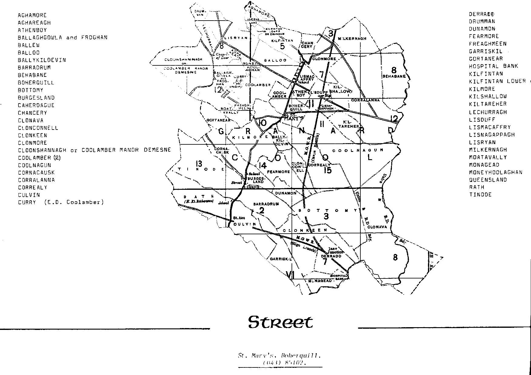
TOWNLANDS IN STREETE PARISH – PARÓISTE AN tSRÁID
Streete:
Anciently called Sraid Mhaighe Breacraigh, i.e. the Street of Moybrackry. This parish occupies the north east corner of the Barony of Ardagh, bordering on Co. Westmeath and lies between the parishes of Granard and Mostrim. It contains 3,377 acres.
(Click on the map to expand it)
In Street Civil Parish there are 18 townlands plus 35 in Streete Civil Parish.
St. Mary’s Streete Roman Catholic Parish includes all 51 townlands.
St. Mary’s church is in Boherquill townland.
| Name of Townland | Logainm | Meaning of Name | |
| Aghamore | *** | Achadh Mór | Great field |
| Aghareagh | *** | Achadh Riabhach | Grey field |
| Athenboy | |||
| Ballaghgowla and Froghan | *** *** | Bealach Gabhla agus An Fraochán | Bealach Gabhlach, forked road Fraochán, bilberry land or land abounding in whortle berries |
| Ballew | |||
| Balloo | *** | Baile Lú | Bal Lugha, Lugh's, or Lewy's town |
| Ballykildevin | |||
| Barradrum | |||
| Behabane | |||
| Boherquill | Bóthar an Choill | ||
| Bottomy | |||
| Burgesland | |||
| Caherdague | *** | Ceathar Déag | |
| Chancery | |||
| Clonava | Cluain ??mha | ||
| Clonconnell | |||
| Clonkeen | |||
| Clonmore | Cluain Mhór | ||
| Cloonshannagh or Coolamber Manor Demesne | *** | Cluain Seannach nó Mainéar Chúil Amra | Lawn or meadow of the foxes Hill-back of the trough |
| Coolamber (2) | *** | Cúil Amra | Hill-back of the trough |
| Coolnagun | Cúil na gCon | ||
| Cornacrusk | |||
| Correaly | |||
| Culvin | Cut bin (now Culvin, in parish of Street) back of peak -- O’Donovan | ||
| Curry | ** | Na Curraithe | A form of Curragh, a marsh |
| Derradd | ** | Doire-fhada | Long oak wood |
| Drumann | *** | An Dromainn | A ridge or long hill |
| Dunamon | |||
| Fearmore | ** | Great grass (feur) or grassy place | |
| Freaghmeen | ** | An Fraoch Mín | Freagh, Freugh, Fraech = heath Mín = fine. Smooth Heath |
| Garriskill | |||
| Gortanear | |||
| Hospital Bank | |||
| Kilfintan | *** | Cill Fhiontain | Fintan's church |
| Kilfintan Lower or Crancam | *** | Cill Fiontain, Fintan's Church Crann Cam = croked tree |
|
| Kilmore | |||
| Kilshallow | |||
| Kiltareher | |||
| Lechurragh | *** | An Leathchurrach | The half moor |
| Lisduff | *** | Lios-dubh | Black fort |
| Lismacaffrey | Lios Mhic Gofraidh | ||
| Lisnagappagh | |||
| Lisryan | Lios Riain | Ryan's fort | |
| Milkernagh | Miolcarnach | ||
| Moatavally | *** | Móta an Bhealaigh | The moat of the road |
| Monagead | |||
| Moneyhoolaghan | Muine Uí Shúileacháin | Móin Uí Shúileacháin O'Sullaghan's bog |
|
| Queensland | Coill Fhiontain Bheag | ||
| Rath | ** | A circular fort | |
| Tinode |
Additional note:
Tupperfintan, St. Fintan’s well
Rev. Wm. Monaghan, P.P., Street, put a stop to the Pattern at St. Fintain’s Well about 40 years ago.
— 0′ Donovan who wrote the above about 1837.
This is a holy well in a place called Queensland, parish of Street. Stations are performed at it on the first Sunday of harvest. Of the Saint’s Church no trace now remains. It is traditionally told that the Saint is interred in a small mound, called on the Ordnance Survey Map Kinard (recte, Ceann-drd)* high head; which mound is to be seen on the bank of a rivulet to the east of Lismacaffrey.
The Saint’s holy well was much neglected till the late Mr. Con Fagan, of Lismacaffrey, erected a cross and pailing around it, and left beside it an At), for drinking its pure water.
* ” There was a nunnery called ‘ Kenard,’ on the lands of Clonmore, parish of Street.” — O’Donovan.
TOWNLANDS IN RATHOWEN PARISH – PARÓISTE RÁTH EOGHAIN

(Click on the map to expand it)
In Rathowen there are two civil parishes.
In Rathowen (Russagh) Civil Parish there are 9 townlands plus 26 in Rathowen (Rathaspick) Civil Parish.
St. Mary’s Rathowen Roman Catholic Parish includes all 35 townlands.
| Name of Townland | Logainm | Meaning of Name | |
| Ballycorkey (part of) | |||
| Ballydorey | |||
| Ballygarran | ** | The town of the garran or shrubbery | |
| Ballygarvey | |||
| Ballygarveybeg | |||
| Bardanstown | |||
| Barratogher | |||
| Cappagh | * | An Cheapach | A plot of land laid down for tillage |
| Carrigagh | |||
| Clonaboy | |||
| Corry | |||
| Corrydonnellan | |||
| Cross | |||
| Crumlin or Rockfield | ** | Cruim-ghlinn | [Crumlin](Four Masters), curved glen |
| Curristeen | |||
| Derrydooan Lower | Doire Dhubháin ??ochtarach | ||
| Derrydooan Middle | Doire Dhubháin Láir | ||
| Derrydooan Upper | Doire Dhubháin Uachtarach | ||
| Henfield | |||
| Joanstown | |||
| Killinagh | |||
| Kilmacahill or Caraun | |||
| Loughanstown | |||
| Loughanstown Lower or Slkievelahan | |||
| Mace | ** | Más | [Mauce], the thigh, a long low hill |
| Newpass Demesne | |||
| Rathaspick | ** | The fort of the bishop (easpug) | |
| Rathclittagh | |||
| Rathowen | Ráth Eoghain | ||
| Rathowen (Edward) | |||
| Russagh | Wood of the steeds | ||
| This place is in the parish of Rathowen, or rather Russagh was formerly joined to Rathowen. "MacRustaing, a famous jester, was buried in Russagh. It is said no woman can look at his grave without uttering a foolish laugh." -- Kuno Meyer. MacRustaing was the maternal brother of St. Coemain Brec, and was probably an ecclesiastic, as he is spoken of as one of the eight distinguished scholars of Armagh, about the year 740. St. Coemain Brec, Abbot of Roseach, died 14th September, 615 A.D. — Dr. Todd. There are at Russagh the ruins of an old church and graveyard, also a mount on which grows a bush said to be the centre of Ireland -- O’Donovan. The horse. We have several words for a horse, the most common are each and capall. Each [agh] is found in several families of languages; the old Irish form is ech; Each is very often found at the beginning of names, contrary to the usual Irish order and in this case it generally takes the modern form of augh. For example Aughinish, an anglicisation of Each-inis (Four Masters), horse island. In the end of names it commonly forms the postfix -agh; as in Russagh in Westmeath, which the Four Masters write Ros-each, the wood of horses – Joyce (p.474) |
|||
| Stongaluggaun | |||
| Windtown | |||
| Windtown North | |||
| Windtown South |